
One of the things I've been thinking about for a while is the the structure of the archaeological record of Earth orbit - all the spacecraft that have been launched over the last 60 years, and their decay products, fragments and molecules of Earth-manufactured materials. Something people ask me occasionally is how you can do archaeology when there is no stratigraphy. In terrestrial archaeology, everything eventually falls to the ground and becomes buried as winds, water and human activities erode higher places and move the sediment to lower places. Generally, the deeper you dig, the older the remains that you find.
This isn't how it works in Earth orbit. Everything's falling, for sure - but a large proportion of stuff never reaches the ground. It's all up there, the new mixed up with the old, the functioning with the defunct, the living with the dead. It's not a mirror of stratigraphy on Earth. The lower something is says nothing about how recent it is.
With one exception - everything in geostationary orbit is younger than 1963, when Syncom 3 became the first satellite to successfully reach this critical orbit, the importance of which for telecommunications had been predicted since the early 20th century. This is just seven years after the first satellite though - not very long. And there's only about 40 satellites left in orbit which date from this period.
The nature of the archaeological record varies according to the gravity you're in. In full Earth gravity, a powerful attractor, things fall. In Earth orbit, things float but can get pulled back to Earth by atmospheric drag. On the Moon, things fall, but more slowly, and less energy is needed to throw them up into orbit. At the five Lagrange points in the Earth-Moon-Sun system, things bounce around. (Indeed, just recently, they have been shown to be massive dust traps).

I prefer to conceptualise the way artefacts respond to variable gravity environments as a dynamical system. This is a visual, mathematical way of representing how objects move over time when certain boundary conditions are set. Objects are the recipients of energy through various sources, and gravity determines how much energy the objects need to move. The dynamical system is a map of places where objects end up as they lose energy - the process of entropy. Effectively, such a map is also an archaeological plan of a site or the surface of an excavation unit. (Now I wonder if we should be regarding our plans as frozen moments in a dynamical system, just one that is generally moving a lot more slowly than orbit. So the critical difference between the two regimes is not speed, but time).
These places are points of stable or unstable equilibrium. When an object falls to the ground, it's in a stable equilibrium place of low energy. To get off the ground, energy has to be added. The energy might come from someone kicking it, or a stream of water which moves it on. The Lagrange points include both stable (L4 and L5) and unstable equilibria (L1, L2 and L3). Unstable equilibrium is like balancing an egg on its pointy end: you can do it, but it's going to fall over pretty quickly. (Also, it helps if the egg is hard-boiled). Using this as a framework, Earth and Earth orbit are not completely different places with different rules, but places within the same system with different amounts of energy.
It also helps to visualise this as an Einsteinian gravity well. The bottoms of the wells are points of low energy and stable equilibrium.
Of course little of the spacecraft is likely to remain in orbit after the main body has re-entered - perhaps some molecules or broken-off bits. When we find the space balls or other Earthbound space junk, it's most likely that this is all that remains of the spacecraft. They've fallen to the point of lowest energy. This includes the spacecraft graveyard at the bottom of the ocean. Earth orbit is bookended by graveyards, if you take into account the graveyard orbit a few hundred kilometres above the geostationary ring. This is where old GEO satellites go to rest in their undead way, as they can still drift down and across the orbits of living satellites.
In general the the structure of space junk is not vertical layers as we're accustomed to in archaeology. Instead, spacecraft decay fragments have an elliptical or cloud geometry. When a spacecraft is whole, all its components are on the one orbital trajectory. Now imagine a solar panel detaching from the main body. Initially, its speed and orbit will be pretty much the same as the main body. But as time passes, the orbits will diverge. If the panel is tracked by one of the Earth-based telescopes, then we will have all the data about it's orbit into the past and will be able to trace it back to the original spacecraft - as long as we keep tracking it.
If a spacecraft explodes, the debris initially forms a cloud around it. The cloud travels together for a little while and then the individual pieces, all with their own weight, size, shape and velocities, start to disperse. If you look at the orbital tracks of Fengyun 1C, the Chinese satellite which was the target of a test missile shot in 2007, the debris rapidly moves apart and starts to spread out as you see here:
Position in orbit is described using a set of six equations devised by Johannes Kepler. Usually what people use, however, is Two-Line Elements - a bit like Eastings and Northings. The position is simplified into two strings of numbers. But because of the non-linear unpredictability of orbits, the reliability of the TLEs diminishes pretty fast. After 30 days you can't be sure that the TLE will accurately predict where something is. What this means in practice is that objects have to be continually watched or tracked to know where they are. This is called persistent observation and it's not generally something archaeologists worry about on Earth. However, artefacts on the surface do move around, although very slowly. You can record a concentration of stone artefacts on the surface, but if you revisit the same site a year later, half of them might be missing. Some have worked their way underground; some are covered by vegetation; others have moved under the influence of wind, water, animal movement or land use and industrial activities. Ten years into the future, there may be nothing to see. So perhaps I should apply the principle of persistent observation to terrestrial archaeology after all...
Objects in space are, of course, moving at incredibly high speeds - an average of 7-8 km per second. It's not that objects within archaeological deposits don't move; soils can act as liquids over a long time period, with a gravity-driven convection that gradually makes artefacts rise higher in the profile. Sometimes objects rise to the surface like a fish and get stranded there. Others, like stone tools with narrow sharp edges, slip back in for re-circulation. This is something archaeologists are very interested in as it says something about the integrity of the site and the relationship between objects. We're looking to that relationship to try and work out the human behavioural correlates, so we need to understand how the relationships decay over time due to natural or cultural factors, such as water movement or scavenger activity.
Effectively, orbital archaeologists of the future will be 'recapitulating' a period of terrestrial archaeology before there was absolute dating, when similarities in style were used to posit chronological and social relationships. This period of investigation is known as culture history, and it worked on a number of premises. The first was the definition of culture, which as V. Gordon Childe phrased it, was a consistently occurring suite of artefact types, features and structures that you could attribute to an ethnic group. The second was the assumption that things change over time, coming in and out of fashion. Graphs of the frequency of occurrence of different artefacts types or styles resembled battleship curves, as they were known. Something starts out at a low frequency, then its numbers increase as it becomes popular. Soon the next big thing starts to supersede it and the frequency declines until no-one makes or uses the object any more. This is pretty much what happens in the fashion industry. Using changing frequencies to date an object is called seriation.
Because atmospheric drag pulls objects out of Low Earth Orbit all the time, things that survive there will be those with the greatest numbers, eg rocket bodies. This makes it a matter of sampling. Future archaeologists may not find the rare satellites as easily as the common ones. It's like the famous section in Kent G. Flannery's The Early Mesoamerican Village, a classic of the 1960s-1970s movement known as the New Archeology. A Real Mesoamerican Archaeologist laughs about another's failure to find the city of Teotihuacan using a particular sampling strategy. The Skeptical Graduate Student explains that this is not the purpose of a sampling strategy - and that the sample should produce results in proportion to what exists in the entire population of artefacts.
In another post I'll consider whether we can apply absolute dating techniques to space junk in orbit.
This isn't how it works in Earth orbit. Everything's falling, for sure - but a large proportion of stuff never reaches the ground. It's all up there, the new mixed up with the old, the functioning with the defunct, the living with the dead. It's not a mirror of stratigraphy on Earth. The lower something is says nothing about how recent it is.
With one exception - everything in geostationary orbit is younger than 1963, when Syncom 3 became the first satellite to successfully reach this critical orbit, the importance of which for telecommunications had been predicted since the early 20th century. This is just seven years after the first satellite though - not very long. And there's only about 40 satellites left in orbit which date from this period.
Multigravity environments
It's more useful not to think of Earth as the standard, but as a special case in a solar system comprising many different levels of gravity and many different ways of experiencing it. For example, when we talk of microgravity in Earth orbit, it's not really that there is no gravity. The Earth is still there, pulling everything towards it as usual. It's the acceleration of falling towards it that creates the sensation of microgravity. You can experience the same thing in a droptower ride at an amusement part or the zero-gravity 'Vomit Comet'. You don't even have to leave Earth to have different gravity experiences!The nature of the archaeological record varies according to the gravity you're in. In full Earth gravity, a powerful attractor, things fall. In Earth orbit, things float but can get pulled back to Earth by atmospheric drag. On the Moon, things fall, but more slowly, and less energy is needed to throw them up into orbit. At the five Lagrange points in the Earth-Moon-Sun system, things bounce around. (Indeed, just recently, they have been shown to be massive dust traps).

Lagrange points in the Earth-Moon-Sun system. Image credit: NASA
I prefer to conceptualise the way artefacts respond to variable gravity environments as a dynamical system. This is a visual, mathematical way of representing how objects move over time when certain boundary conditions are set. Objects are the recipients of energy through various sources, and gravity determines how much energy the objects need to move. The dynamical system is a map of places where objects end up as they lose energy - the process of entropy. Effectively, such a map is also an archaeological plan of a site or the surface of an excavation unit. (Now I wonder if we should be regarding our plans as frozen moments in a dynamical system, just one that is generally moving a lot more slowly than orbit. So the critical difference between the two regimes is not speed, but time).
These places are points of stable or unstable equilibrium. When an object falls to the ground, it's in a stable equilibrium place of low energy. To get off the ground, energy has to be added. The energy might come from someone kicking it, or a stream of water which moves it on. The Lagrange points include both stable (L4 and L5) and unstable equilibria (L1, L2 and L3). Unstable equilibrium is like balancing an egg on its pointy end: you can do it, but it's going to fall over pretty quickly. (Also, it helps if the egg is hard-boiled). Using this as a framework, Earth and Earth orbit are not completely different places with different rules, but places within the same system with different amounts of energy.
It also helps to visualise this as an Einsteinian gravity well. The bottoms of the wells are points of low energy and stable equilibrium.
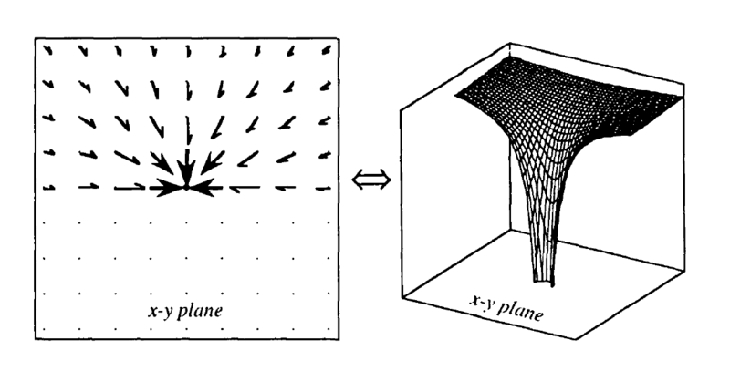 |
| A 2-D slice of a gravitational force vector field (left) is interchangeable with a 3-D gravity well (right), with the z-axis showing energy (potential). Image courtesy of Invent2HelpAll |
How junk disperses, or a taphonomy of orbit
In fact, the stratigraphy of space junk does include a terrestrial component. The lowest point of energy in the orbital dynamical system is the surface of Earth: an orbit of zero apogee and perigee. The atmosphere is a barrier or boundary between different gravity regimes, as space objects can bounce off its upper surface, and those that get pulled into it tend to incinerate. However, some spacecraft parts are made of materials like stainless steel and titanium alloys, which have high melting temperatures. Other parts may have carbon-carbon insulation which provides some protection from temperature extremes. Sometimes these components scream at high speed into the atmosphere, with their flesh burning, and fall with a smoking thud to the surface. The so-called 'space balls', titanium pressure vessels, are one of the most common spacecraft parts to survive re-entry. These spheres are the best gravity travellers; they get to come back.Of course little of the spacecraft is likely to remain in orbit after the main body has re-entered - perhaps some molecules or broken-off bits. When we find the space balls or other Earthbound space junk, it's most likely that this is all that remains of the spacecraft. They've fallen to the point of lowest energy. This includes the spacecraft graveyard at the bottom of the ocean. Earth orbit is bookended by graveyards, if you take into account the graveyard orbit a few hundred kilometres above the geostationary ring. This is where old GEO satellites go to rest in their undead way, as they can still drift down and across the orbits of living satellites.
In general the the structure of space junk is not vertical layers as we're accustomed to in archaeology. Instead, spacecraft decay fragments have an elliptical or cloud geometry. When a spacecraft is whole, all its components are on the one orbital trajectory. Now imagine a solar panel detaching from the main body. Initially, its speed and orbit will be pretty much the same as the main body. But as time passes, the orbits will diverge. If the panel is tracked by one of the Earth-based telescopes, then we will have all the data about it's orbit into the past and will be able to trace it back to the original spacecraft - as long as we keep tracking it.
If a spacecraft explodes, the debris initially forms a cloud around it. The cloud travels together for a little while and then the individual pieces, all with their own weight, size, shape and velocities, start to disperse. If you look at the orbital tracks of Fengyun 1C, the Chinese satellite which was the target of a test missile shot in 2007, the debris rapidly moves apart and starts to spread out as you see here:
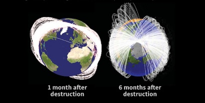 |
| Fengyun 1C debris evolution. Image by Karl Tate @space.com |
Position in orbit is described using a set of six equations devised by Johannes Kepler. Usually what people use, however, is Two-Line Elements - a bit like Eastings and Northings. The position is simplified into two strings of numbers. But because of the non-linear unpredictability of orbits, the reliability of the TLEs diminishes pretty fast. After 30 days you can't be sure that the TLE will accurately predict where something is. What this means in practice is that objects have to be continually watched or tracked to know where they are. This is called persistent observation and it's not generally something archaeologists worry about on Earth. However, artefacts on the surface do move around, although very slowly. You can record a concentration of stone artefacts on the surface, but if you revisit the same site a year later, half of them might be missing. Some have worked their way underground; some are covered by vegetation; others have moved under the influence of wind, water, animal movement or land use and industrial activities. Ten years into the future, there may be nothing to see. So perhaps I should apply the principle of persistent observation to terrestrial archaeology after all...
Objects in space are, of course, moving at incredibly high speeds - an average of 7-8 km per second. It's not that objects within archaeological deposits don't move; soils can act as liquids over a long time period, with a gravity-driven convection that gradually makes artefacts rise higher in the profile. Sometimes objects rise to the surface like a fish and get stranded there. Others, like stone tools with narrow sharp edges, slip back in for re-circulation. This is something archaeologists are very interested in as it says something about the integrity of the site and the relationship between objects. We're looking to that relationship to try and work out the human behavioural correlates, so we need to understand how the relationships decay over time due to natural or cultural factors, such as water movement or scavenger activity.
It's the relationship that matters
Both inside Earth and in orbit, the way the relationships between objects within a space evolves over time is critical to working out the human behavioural component. Looking at how the space debris environment evolves, it seems that after a certain amount of time it would be impossible to reconstruct the orbital path and work out what spacecraft a piece of junk came from, if you did not already have tracking records. Let's imagine the scenario of a future human archaeologist after the records have vanished (we can't assume they will survive in their current form) or even an alien archaeologist looking at space debris to get a handle on Earth culture. They will initially use materials and style to identify which space objects belong in the same time frame or to the same culture. They'll also have to work out what differences are due to style, and which to function.Effectively, orbital archaeologists of the future will be 'recapitulating' a period of terrestrial archaeology before there was absolute dating, when similarities in style were used to posit chronological and social relationships. This period of investigation is known as culture history, and it worked on a number of premises. The first was the definition of culture, which as V. Gordon Childe phrased it, was a consistently occurring suite of artefact types, features and structures that you could attribute to an ethnic group. The second was the assumption that things change over time, coming in and out of fashion. Graphs of the frequency of occurrence of different artefacts types or styles resembled battleship curves, as they were known. Something starts out at a low frequency, then its numbers increase as it becomes popular. Soon the next big thing starts to supersede it and the frequency declines until no-one makes or uses the object any more. This is pretty much what happens in the fashion industry. Using changing frequencies to date an object is called seriation.
Because atmospheric drag pulls objects out of Low Earth Orbit all the time, things that survive there will be those with the greatest numbers, eg rocket bodies. This makes it a matter of sampling. Future archaeologists may not find the rare satellites as easily as the common ones. It's like the famous section in Kent G. Flannery's The Early Mesoamerican Village, a classic of the 1960s-1970s movement known as the New Archeology. A Real Mesoamerican Archaeologist laughs about another's failure to find the city of Teotihuacan using a particular sampling strategy. The Skeptical Graduate Student explains that this is not the purpose of a sampling strategy - and that the sample should produce results in proportion to what exists in the entire population of artefacts.
In another post I'll consider whether we can apply absolute dating techniques to space junk in orbit.
Topological stratigraphy
Terrestrial stratigraphy is locally linear and Euclidean, but orbits are non-linear and non-Euclidean. At larger scales, space is better described as the topological object called a manifold. Stratigraphy might simply be the wrong concept to describe the structure of orbiting objects. What kind of word would we use instead? Perhaps gravigraphy - written in gravity? Or orbitography, which is 'the determination and positioning of satellite orbits by a form of geodesy'?Visualisations of space junk show Earth surrounded by white dots, like a cloud of silent bees. If you took Earth out of the middle, you would have a donut shape or torus where geostationary satellites are concentrated, and perhaps a series of intersecting tori for low to medium Earth orbit satellites. This is in stark contrast to terrestrial stratigraphy, which is conceptualised in a box-shape (even though Earth is spherical). Objects in this gravitationally-constrained tori move on elliptical paths inside the shape.
Let's put Earth back in. If we sliced a wedge vertically through through this cloud or swam, and froze the objects within it, what would we see? At the outer edge, the graveyard orbit, there'd be a thin smattering of defunct satellites. They are all dead. Below it, in the GEO range, there is thick ring of living and dead satellites. The 'type fossil' of this layer is the winged bird.
Then there is a sparse background scatter of satellites and junk until we hit the navigation satellites in the Medium Earth Orbit range. The US GPS network orbit at around 20, 000 km.
In LEO, we get the highest density of rocket bodies as well as satellites. There is a more diverse size range, from ENVISAT, the International Space Station, to cubesats and nanosats. There is the sparsest smattering of organic material.
There's a dead zone from LEO to the height of the tallest building or structure on Earth. Birds and aeroplanes fly at different altitudes, but they don't stay there or live there. There are gases, clouds, dusts.
On the surface of Earth, the ancient is mixed up with the modern. I suppose it is more like orbit than we might think, the living and the dead jostling side by side. Organic material is dense. Movement is slow. The deeper you go under the surface, the older things become. In this subterranean sphere, everything human is dead.
In all of these layers, the past and the present are mixed up to different degrees. The closer to the present you get, the higher and deeper human culture goes. Mines and building foundations cut into the dead deep past and overlay it with modern material. This is the variable borderland between the Pleistocene, Holocene and Anthropocene, a diachronous boundary that archaeologist Matt Edgeworth and his co-authors (2015) have discussed in an insightful paper (see below).
What is a place in orbit?
I'm relatedly curious about the concepts of setting or site in the orbital environment. Here, a 'place' is really a set of equations that defines the way an object moves - not just now but in the past and into the future. Place is a prediction, effectively. Place is movement, not stasis.
Could an orbital pathway, in and of itself, have heritage significance? Could it be 'preserved', and what would be the relationship between a culturally significant trajectory and the equations that define it? Could those equations, in and of themselves, also be considered culturally or archaeologically significant?
Perhaps in the future, there will be markers along the orbits of significant spacecraft that are not longer there, alerting anyone/thing who approaches that they are at a heritage orbit. Perhaps certain orbits - like Vanguard 1's - could be registered as significant so that nobody can launch something into the same orbit. An orbit has economic significance - so why not heritage significance too?
I think I have a lot further to go in this line of thinking. But it's a start anyway.
Could an orbital pathway, in and of itself, have heritage significance? Could it be 'preserved', and what would be the relationship between a culturally significant trajectory and the equations that define it? Could those equations, in and of themselves, also be considered culturally or archaeologically significant?
Perhaps in the future, there will be markers along the orbits of significant spacecraft that are not longer there, alerting anyone/thing who approaches that they are at a heritage orbit. Perhaps certain orbits - like Vanguard 1's - could be registered as significant so that nobody can launch something into the same orbit. An orbit has economic significance - so why not heritage significance too?
I think I have a lot further to go in this line of thinking. But it's a start anyway.
References
Matt Edgeworth, Dan deB Richter, Colin Waters, Peter Haff, Cath Neal, and Simon James Price 2015 Diachronous beginnings of the Anthropocene: the lower bounding surface of anthropogenic deposits. The Anthropocene Review 2(1):33-58Flannery, Kent G. (ed) 1976 The Early Mesoamerican Village. Academic Press


